A few days ago I was at the IEC history of computing museum where they also exhibited their progress in map making – from old blueprints and paper maps to modern CAD and GIS software. They had there an old 1960’s map that caught my eye – a 1:50,000 topographic map by the Israel Survey Department. These were the best you could get when I was a kid hiking around the country; every house was correctly shown as a black dot of the exact right shape, and every hill and gully were visible in the contour lines.
I looked at the map and it struck me how much maps’ visual quality has progressed since then, with modern printing techniques. The stark colors used in the 60’s are replaced today with delicate pastels; the topography is enhanced by fine shading; the important details are not drowned out by the density of equally strong contour lines. The information of the old maps was perhaps perfect, but to the modern eye they look, well… old. Unfortunately, as far as I know the maps you can buy today at such a detailed scale use the same old techniques.
Then the next day I came to see a new Israel Survey Department map that was wondrous fine to behold, done in pastel shades and fine shading gradations, reminiscent of what you see in Google Maps but with all the detail of the maps of my youth. And my friend Gadi happened by, and I said unto him, lo, see this map, for it is very finely done, and only the other day had I wished such were made; and he looked upon the map and found it good. And I said to him, surely I should blog about this map and compare it to the older ones, and he said, verily thou shouldst. And I resolved to make it so. And then the matter passed from my mind until my alarm clock went off to wake me for my day’s labors.
The bad news is, evidently the Israel Survey Dept. has yet to produce the fine map I saw in my dream. The good news is, looks like my blogging has reached the point where it passes the immersion test. I’ve found long ago that when I really immerse myself in some practice or task, it makes its way into my dreams. As a forensic scientist, I would dream of Gunshot Residue Particles; as a Thin Films VLSI engineer I would examine LTO defects in dreamland; and when I took to developing software, I would dream at times of bugs – I remember once actually solving a particularly stubborn one in my sleep, a solution that turned out to be valid in real life. So now I dream of searching for stuff to blog about!
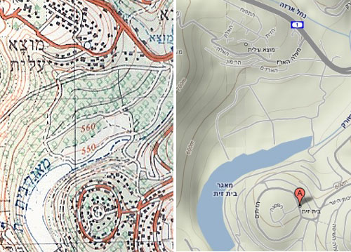
As for my resolution, I can’t show you the nonexistent topographic map, but I can and hereby do show you a comparison of an old ISD map and a detail of the same area from Google Maps (Terrain option) that illustrates the visual qualities I was dreaming of merging with it.


1 Response to “My blogging passes the immersion test!”